
In the world of cartography, the beauty of the Earth's topography is not just in the heights and depths of its landscapes but in the way these dimensions are captured and conveyed. Among the myriad ways to represent terrain, shaded relief maps hold a special place for their ability to depict the natural beauty and three-dimensionality of the Earth's surface. Let's dive into the world of shaded relief maps and see how they compare with other types of topographic maps.
The Art of Shaded Relief Maps
Shaded relief maps, sometimes known as hill-shading, provide a visually intuitive representation of the Earth's surface. These maps use simulated light and shadow to create the illusion of three-dimensional landscapes on a two-dimensional surface. The technique highlights the natural features of the terrain, such as mountains, valleys, and plateaus, allowing viewers to appreciate the contours of the land almost as if they were viewing it in person. At East of Nowhere, our shaded relief maps are crafted to bring out the most minute details and subtleties of the terrain, creating a near-3D effect that captivates and educates.
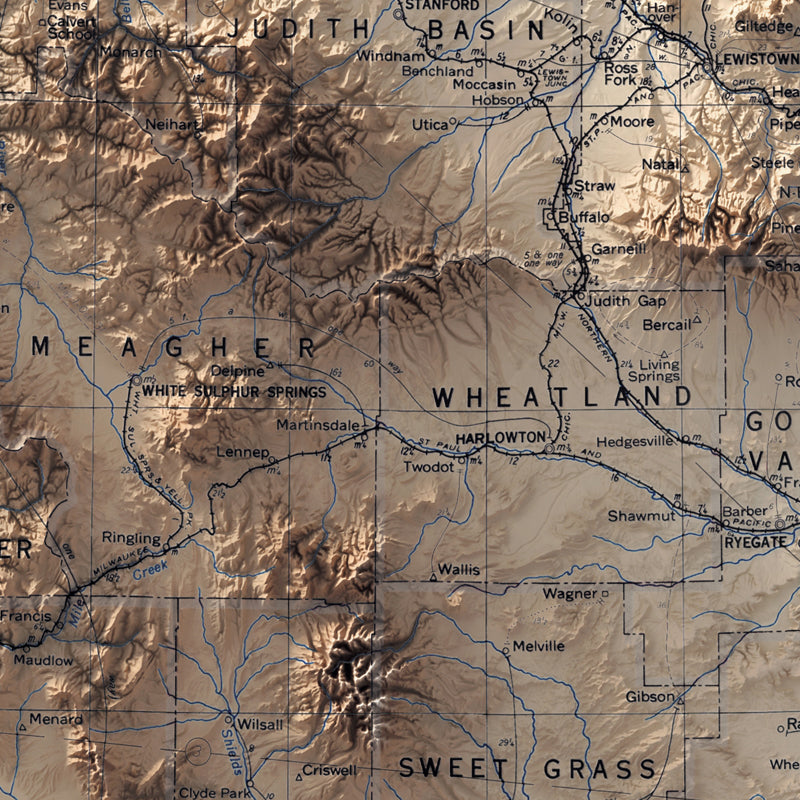
Example of a Shaded Relief Map of Montana (Central Region)
Shaded Relief vs. Contour Lines
Topographic maps often use contour lines to denote elevation. While contour lines are incredibly useful for understanding exact heights and the steepness of slopes, they require interpretation and can sometimes clutter a map, making it difficult to visualize the landscape. Shaded relief maps, by contrast, offer an immediate, intuitive understanding of the terrain. The interplay of light and shadow on these maps makes the topography "pop," providing a quick grasp of the landscape's overall shape and form without the need for interpretation.
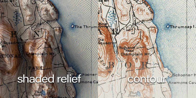
Shaded relief compared to a standard contour map (Bar Harbor, Maine)
Shaded Relief vs. Color Elevation
Another common method of representing topography is through color elevation maps, where different colors represent different elevations. While color elevation maps are effective at providing a clear overview of height variations across a landscape, they lack the nuanced detail and realism of shaded relief maps. Shaded relief maps, with their dynamic interplay of light and shadow, offer a more natural and lifelike representation of the terrain, closely mimicking how it would appear under natural lighting conditions.
The Unique Value of Shaded Relief Maps
The unique value of shaded relief maps lies in their ability to merge art with science. By simulating natural lighting, these maps provide a more relatable and immersive experience, allowing viewers to feel as if they are gazing upon the actual terrain. This makes shaded relief maps not just tools for navigation or study but pieces of art that celebrate the Earth's diverse landscapes. At East of Nowhere, our maps are designed to be both aesthetically pleasing and highly informative, making them perfect for education, planning, or simply as a stunning addition to any room.
While each type of topographic map has its advantages and uses, shaded relief maps offer a unique blend of realism, beauty, and functionality. They allow us to appreciate the natural world from the comfort of our own homes, providing a window into the diverse landscapes that make up our planet. At East of Nowhere, we are committed to crafting maps that not only guide but inspire. Explore our collection of shaded relief maps and bring the beauty of the Earth's topography into your life.